
|
View Larger Image |
"A plan of the town of Boston, with the intrenchments &c. of His Majestys forces in 1775" This map, created by Sir Thomas Hyde Page, a lieutenant and military engineer in the king's forces, was published in London in 1777. This image provides one of the most detailed depictions available of Boston in this period. Street names; important buildings, such as the town's many churches, Faneuil Hall, and workhouses; and defensive structures are all noted. The many wharves, as well as the prominence of the Long Wharf, extending far into the harbor on the right side of the image, serve to underline the commercial economy and orientation of the community. To explore the town's features, use the Library of Congress interactive map. If you move west from the Long Wharf, you will come to the location of one of Murray's shops, which was at the northwest corner of the intersection of Cornhill and Queen Street, just beyond the Town Hall. Note: from "The American Revolution and Its Era: Maps and Charts of North America and the West Indies, 1750-1789." Library of Congress Geography and Map Division, Washington D.C. |
||
|
|||
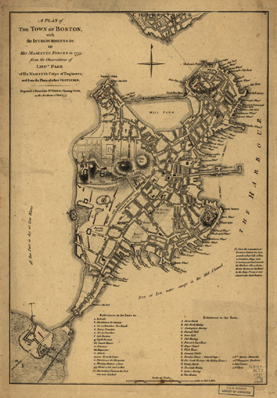 "A plan of the town of Boston, with the intrenchments &c. of His Majestys forces in 1775." From the observations of Lieut. Page of His Majesty's Corps of Engineers; and from the plans of other gentlemen. The American Memory Collection, Library of Congress Geography and Map Division Washington, D.C.
