
|
View Larger Image |
Introduction:This map, published in London in 1778, presented the state of siege that existed after hostilties erupted in Lexington and Concord in April 1775. By the time this map was printed, the war news it conveyed was somewhat dated. The map nonetheless reveals important details of Boston's harbor and town features, such as the shoreline and prominent wharves. The image also underlines the colonial shape of the town, with the peninsula of Boston connected to the surrounding land by a narrow neck. For a close-up view of these features, go to the interactive map at the Library of Congress, where you can zoom in to inspect the town. Note: from "The American Revolution and Its Era: Maps and Charts of North America and the West Indies, 1750-1789," American Memory Collection, Library of Congress Geography and Map Division Washington, D.C. |
||
|
|||
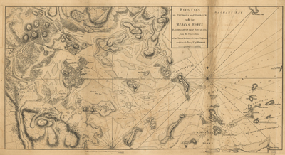 Boston, its environs and harbour, with the rebels works raised against that town in 1775. From the observations of Lieut. Page of His Majesty's Corps of Engineers, and from the plans of Capt. Montresor. American Memory Collection, Library of Congress Geography and Map Division Washington, D.C.
